Our Town Almanac
Fayetteville, Tennessee The Fayetteville Almanacpart of Our Town Almanac · directory, events, history & people · Lincoln County, Tennessee · ZIP 37334

North side of the square: College St. E.

12 buildings. Walk east to west, from Elk Ave. back to Main Ave.

  1. 134
  2. 128
  3. 124
  4. College St. E.
  5. 120
  6. 116
  7. 114
  8. 112
  9. 108
  10. 104
  11. 102
  12. 100

Each card gives what the old fire insurance maps show for the storefront, 1887 to 1926, with the label as printed and a link to the map sheet. Old lots are matched to today’s addresses by our reading of the maps against county property lines. How to read these cards · All sources

Across Main Ave. from the northwest corner is the Pythian Building, stop 3 on the walking tour.

North side · College St. E.

134 College St. E.

Office and jeweler’s corner

Today

From our directory, Oct. 21, 2026. Please check with a business before you go.

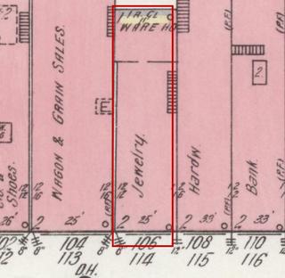
On the old maps (no. 124 in 1914)

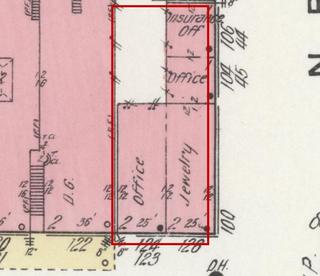
April 1914 Sanborn fire insurance map detail with the lot at today’s 134 College St. E. outlined in red; the map labels it: an office and a jeweler
Then: 1914 map
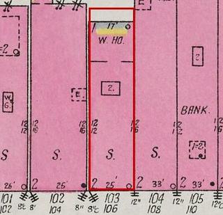
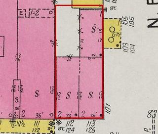
September 1926 Sanborn fire insurance map detail with the lot at today’s 134 College St. E. outlined in red; the map labels it: two stores
1926 map

Maps: Sanborn Map Co., April 1914, sheet 9, Library of Congress (public domain); Sept. 1926, sheet 5, UT Knoxville Libraries (No Copyright – United States). Cropped; red outline added by Our Town Almanac.
  1. 1907 Barber; jeweler map label: Barber; Jewelry Library of Congress, sheet 2
  2. 1914 An office and a jeweler map label: Office (124); Jewelry (126) Library of Congress, sheet 9
  3. 1926 Two stores map label: S.; S. UT Knoxville Libraries, sheet 5

Local history says: Jewelry businesses operated on this corner for over a century. (Fayetteville Main Street, History)

Local history says: The basement has an old fireplace, and some building materials were judged to be pre-Civil War and reused. (Fayetteville Main Street, History)

North side · College St. E.

128 College St. E. (also 132)

Dry-goods store with the Masonic hall upstairs

Today

From our directory, Oct. 21, 2026. Please check with a business before you go.

On the old maps (no. 122 in 1914)

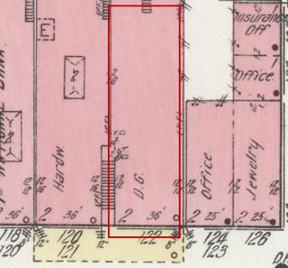
April 1914 Sanborn fire insurance map detail with the lot at today’s 128 College St. E. outlined in red; the map labels it: dry goods
Then: 1914 map
September 1926 Sanborn fire insurance map detail with the lot at today’s 128 College St. E. outlined in red; the map labels it: store
1926 map

Maps: Sanborn Map Co., April 1914, sheet 9, Library of Congress (public domain); Sept. 1926, sheet 5, UT Knoxville Libraries (No Copyright – United States). Cropped; red outline added by Our Town Almanac.
  1. 1887 Grocery; the Masonic hall upstairs map label: Gro.; Masonic Hall 2nd Library of Congress, sheet 1
  2. 1891 Grocery; the Masonic hall and a milliner upstairs map label: Gro.; Masonic Hall & Mill'y 2nd Library of Congress, sheet 3
  3. 1897 Grocery; a milliner upstairs map label: Gro.; Mill'y 2nd Library of Congress, sheet 3
  4. 1902 Dry goods map label: D.G. Library of Congress, sheet 2
  5. 1907 Dry goods, boots and shoes map label: D.G. & B. & S. Library of Congress, sheet 2
  6. 1914 Dry goods map label: D.G. Library of Congress, sheet 9
  7. 1926 Store map label: S. UT Knoxville Libraries, sheet 5

North side · College St. E.

124 College St. E.

Hardware store

Today

No business is listed at this address in our directory. Know what’s here? Tell us.

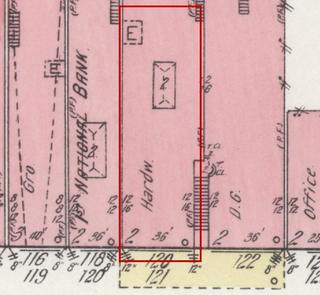
On the old maps (no. 120 in 1914)

April 1914 Sanborn fire insurance map detail with the lot at today’s 124 College St. E. outlined in red; the map labels it: hardware
Then: 1914 map
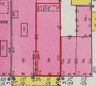
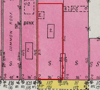
September 1926 Sanborn fire insurance map detail with the lot at today’s 124 College St. E. outlined in red; the map labels it: store
1926 map

Maps: Sanborn Map Co., April 1914, sheet 9, Library of Congress (public domain); Sept. 1926, sheet 5, UT Knoxville Libraries (No Copyright – United States). Cropped; red outline added by Our Town Almanac.
  1. 1887 Hardware map label: Hardw. Library of Congress, sheet 1
  2. 1891 Hardware and carriages map label: Hardw. & Carriages Library of Congress, sheet 3
  3. 1897 Hardware and carriages map label: Hardware & Carriage Library of Congress, sheet 3
  4. 1902 Hardware and carriages map label: Hardw. & Carriage Library of Congress, sheet 2
  5. 1907 Hardware and carriages map label: Hardware & Carriages Library of Congress, sheet 2
  6. 1914 Hardware map label: Hardw. Library of Congress, sheet 9
  7. 1926 Store map label: S. UT Knoxville Libraries, sheet 5

Local history says: A hardware company has occupied the east side of this building for over 130 years. (Fayetteville Main Street, History)

North side · College St. E.

College St. E., between 120 and 124

The First National Bank

Today

No business is listed at this address in our directory. Know what’s here? Tell us.

The county parcel here has no street number; the Lincoln County 911 address point on it is 124.

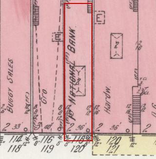
On the old maps (no. 118 in 1914)

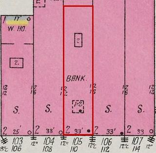
April 1914 Sanborn fire insurance map detail with the lot at today’s College St. E., between 120 and 124 outlined in red; the map labels it: first national bank
Then: 1914 map
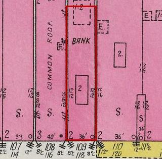
September 1926 Sanborn fire insurance map detail with the lot at today’s College St. E., between 120 and 124 outlined in red; the map labels it: bank
1926 map

Maps: Sanborn Map Co., April 1914, sheet 9, Library of Congress (public domain); Sept. 1926, sheet 5, UT Knoxville Libraries (No Copyright – United States). Cropped; red outline added by Our Town Almanac.
  1. 1887 Bank Library of Congress, sheet 1
  2. 1891 First National Bank map label: First Nat'l Bank Library of Congress, sheet 3
  3. 1897 First National Bank map label: 1st National Bank Library of Congress, sheet 3
  4. 1902 First National Bank map label: 1st Nat'l Bank Library of Congress, sheet 2
  5. 1907 First National Bank map label: 1st National Bank Library of Congress, sheet 2
  6. 1914 First National Bank map label: 1st National Bank Library of Congress, sheet 9
  7. 1926 Bank UT Knoxville Libraries, sheet 5

Local history says: From the 1870s, for nearly a century, a bank occupied the west side of this building and a hardware company the east side. (Fayetteville Main Street, History)

North side · College St. E.

120 College St. E. (also 122)

A buggy store and a grocery in 1914

Today

From our directory, Oct. 21, 2026. Please check with a business before you go.

One county parcel today (911 address points 120 and 122); on the maps it was two storefronts.

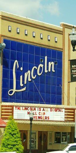
Front of the Lincoln Theatre: a tall blue tile panel with Lincoln in white script above the marquee, yellow brick on each side, College St. E., 2015
Now: 2015 photo. The maps below show the two storefronts this building covered in 1914 and 1926. Photo (2015, cropped): Brian Stansberry, CC BY 3.0, via Wikimedia Commons.

On the old maps: storefront 1 of 2, no. 116 on the 1914 map

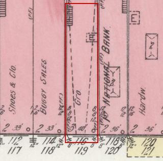
April 1914 Sanborn fire insurance map detail with the lot at today’s 120 College St. E. (storefront 1 of 2) outlined in red; the map labels it: grocery
Then: 1914 map
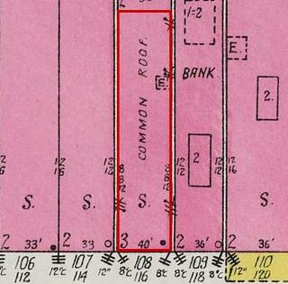
September 1926 Sanborn fire insurance map detail with the lot at today’s 120 College St. E. (storefront 1 of 2) outlined in red; the map labels it: store
1926 map

Maps: Sanborn Map Co., April 1914, sheet 9, Library of Congress (public domain); Sept. 1926, sheet 5, UT Knoxville Libraries (No Copyright – United States). Cropped; red outline added by Our Town Almanac.
  1. 1907 Grocery; an office upstairs map label: Gro.; Office 2nd Library of Congress, sheet 2
  2. 1914 Grocery map label: Gro. Library of Congress, sheet 9
  3. 1926 Store map label: S. UT Knoxville Libraries, sheet 5

The maps show: In 1891 the upper floor was labeled "Y.M.C.A. Hall." (Library of Congress, sheet 3)

On the old maps: storefront 2 of 2, no. 114 on the 1914 map

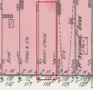
April 1914 Sanborn fire insurance map detail with the lot at today’s 120 College St. E. (storefront 2 of 2) outlined in red; the map labels it: buggy sales
Then: 1914 map
September 1926 Sanborn fire insurance map detail with the lot at today’s 120 College St. E. (storefront 2 of 2) outlined in red; the map labels it: store
1926 map

Maps: Sanborn Map Co., April 1914, sheet 9, Library of Congress (public domain); Sept. 1926, sheet 5, UT Knoxville Libraries (No Copyright – United States). Cropped; red outline added by Our Town Almanac.
  1. 1887 Dry goods and shoes map label: D.G. & S. Library of Congress, sheet 1
  2. 1907 Wagons Library of Congress, sheet 2
  3. 1914 Buggy sales map label: Buggy Sales Library of Congress, sheet 9
  4. 1926 Store map label: S. UT Knoxville Libraries, sheet 5

North side · College St. E.

116 College St. E.

Shoe and clothing store

Today

From our directory, Oct. 21, 2026. Please check with a business before you go.

On the old maps (no. 112 in 1914)

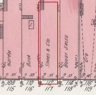
April 1914 Sanborn fire insurance map detail with the lot at today’s 116 College St. E. outlined in red; the map labels it: shoes and clothing
Then: 1914 map
September 1926 Sanborn fire insurance map detail with the lot at today’s 116 College St. E. outlined in red; the map labels it: store
1926 map
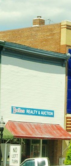
Two-story storefront with white metal siding over the upper floor, a red awning and a blue Bolles Realty & Auction sign, College St. E., 2015
Now: 2015 photo

Maps: Sanborn Map Co., April 1914, sheet 9, Library of Congress (public domain); Sept. 1926, sheet 5, UT Knoxville Libraries (No Copyright – United States). Cropped; red outline added by Our Town Almanac. Photo (2015, cropped): Brian Stansberry, CC BY 3.0, via Wikimedia Commons.
  1. 1887 General store map label: Gen'l S. Library of Congress, sheet 1
  2. 1907 Racket (variety) store map label: Racket S. Library of Congress, sheet 2
  3. 1914 Shoes and clothing map label: Shoes & Clo. Library of Congress, sheet 9
  4. 1926 Store map label: S. UT Knoxville Libraries, sheet 5

North side · College St. E.

114 College St. E.

Bank building

Today

From our directory, Oct. 21, 2026. Please check with a business before you go.

On the old maps (no. 110 in 1914)

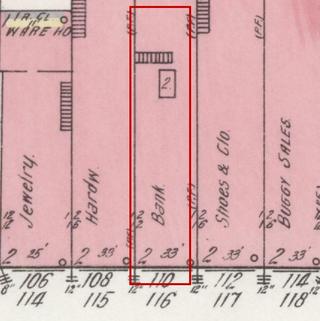
April 1914 Sanborn fire insurance map detail with the lot at today’s 114 College St. E. outlined in red; the map labels it: bank
Then: 1914 map
September 1926 Sanborn fire insurance map detail with the lot at today’s 114 College St. E. outlined in red; the map labels it: bank
1926 map
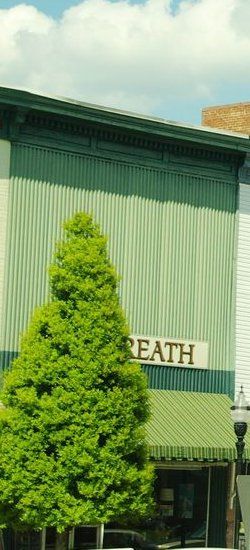
Two-story storefront with green metal siding over the upper floor, a green striped awning and a sign ending in REATH partly hidden by a small tree, College St. E., 2015
Now: 2015 photo

Maps: Sanborn Map Co., April 1914, sheet 9, Library of Congress (public domain); Sept. 1926, sheet 5, UT Knoxville Libraries (No Copyright – United States). Cropped; red outline added by Our Town Almanac. Photo (2015, cropped): Brian Stansberry, CC BY 3.0, via Wikimedia Commons.
  1. 1887 Bank Library of Congress, sheet 1
  2. 1891 Bank of Fayetteville Library of Congress, sheet 3
  3. 1897 Insurance office map label: Ins. Off. Library of Congress, sheet 3
  4. 1902 Jeweler map label: Jewelry Library of Congress, sheet 2
  5. 1907 Bank Library of Congress, sheet 2
  6. 1914 Bank Library of Congress, sheet 9
  7. 1926 Bank UT Knoxville Libraries, sheet 5

North side · College St. E.

112 College St. E.

Hardware store

Today

From our directory, Oct. 21, 2026. Please check with a business before you go.

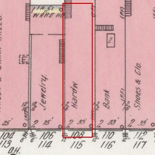
On the old maps (no. 108 in 1914)

April 1914 Sanborn fire insurance map detail with the lot at today’s 112 College St. E. outlined in red; the map labels it: hardware
Then: 1914 map
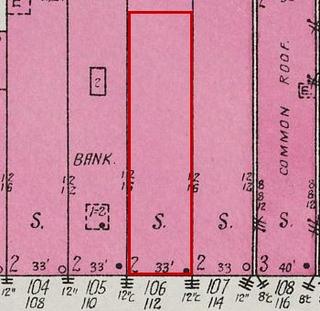
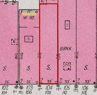
September 1926 Sanborn fire insurance map detail with the lot at today’s 112 College St. E. outlined in red; the map labels it: store
1926 map
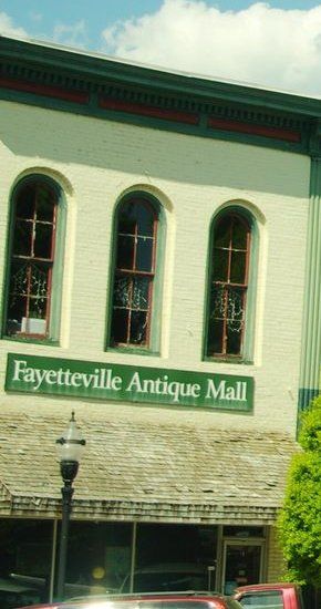
Two-story cream-painted brick storefront with three arched upper windows and a green Fayetteville Antique Mall sign over the awning, College St. E., 2015
Now: 2015 photo

Maps: Sanborn Map Co., April 1914, sheet 9, Library of Congress (public domain); Sept. 1926, sheet 5, UT Knoxville Libraries (No Copyright – United States). Cropped; red outline added by Our Town Almanac. Photo (2015, cropped): Brian Stansberry, CC BY 3.0, via Wikimedia Commons.
  1. 1887 Grocery map label: Gro. Library of Congress, sheet 1
  2. 1907 Hardware and implements map label: Hardware & Implements Library of Congress, sheet 2
  3. 1914 Hardware map label: Hardw. Library of Congress, sheet 9
  4. 1926 Store map label: S. UT Knoxville Libraries, sheet 5

North side · College St. E.

108 College St. E.

Drugstore, then jeweler

Today

From our directory, Oct. 21, 2026. Please check with a business before you go.

On the old maps (no. 106 in 1914)

April 1914 Sanborn fire insurance map detail with the lot at today’s 108 College St. E. outlined in red; the map labels it: jeweler
Then: 1914 map
September 1926 Sanborn fire insurance map detail with the lot at today’s 108 College St. E. outlined in red; the map labels it: store
1926 map

Maps: Sanborn Map Co., April 1914, sheet 9, Library of Congress (public domain); Sept. 1926, sheet 5, UT Knoxville Libraries (No Copyright – United States). Cropped; red outline added by Our Town Almanac.
  1. 1887 Drugstore map label: Drugs Library of Congress, sheet 1
  2. 1891 Drugs, varnish and paint (oil stored in the cellar) map label: Drugs, Varnish & Paint, Oil in cellar Library of Congress, sheet 3
  3. 1897 Drugs, varnish and paints (oil stored in the cellar) map label: Drugs, Varnish & Paints, Oil in cellar Library of Congress, sheet 3
  4. 1902 Drugs, varnish and paints (oil stored in the cellar) map label: Drugs, Varnish & Paints, Oil in cellar Library of Congress, sheet 2
  5. 1907 Drugs, varnish and paints (oil stored in the cellar) map label: Drugs Varnish & Paints, Oil in cellar Library of Congress, sheet 2
  6. 1914 Jeweler map label: Jewelry Library of Congress, sheet 9
  7. 1926 Store map label: S. UT Knoxville Libraries, sheet 5

North side · College St. E.

104 College St. E.

Wagon and grain store

Today

No business is listed at this address in our directory. Know what’s here? Tell us.

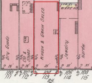
On the old maps (no. 104 in 1914)

April 1914 Sanborn fire insurance map detail with the lot at today’s 104 College St. E. outlined in red; the map labels it: wagon and grain sales
Then: 1914 map
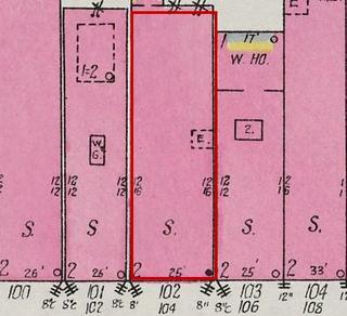
September 1926 Sanborn fire insurance map detail with the lot at today’s 104 College St. E. outlined in red; the map labels it: store
1926 map

Maps: Sanborn Map Co., April 1914, sheet 9, Library of Congress (public domain); Sept. 1926, sheet 5, UT Knoxville Libraries (No Copyright – United States). Cropped; red outline added by Our Town Almanac.
  1. 1887 Grocery map label: Gro. Library of Congress, sheet 1
  2. 1891 Grocery map label: Gro. Library of Congress, sheet 3
  3. 1897 Grocery map label: Gro. Library of Congress, sheet 3
  4. 1902 Grocery map label: Gro. Library of Congress, sheet 2
  5. 1907 Grocery map label: Gro. Library of Congress, sheet 2
  6. 1914 Wagon and grain sales map label: Wagon & Grain Sales Library of Congress, sheet 9
  7. 1926 Store map label: S. UT Knoxville Libraries, sheet 5

North side · College St. E.

102 College St. E.

Clothing and shoe store

Today

From our directory, Oct. 21, 2026. Please check with a business before you go.

On the old maps (no. 102 in 1914)

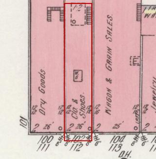
April 1914 Sanborn fire insurance map detail with the lot at today’s 102 College St. E. outlined in red; the map labels it: clothing and shoes
Then: 1914 map
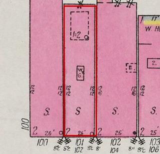
September 1926 Sanborn fire insurance map detail with the lot at today’s 102 College St. E. outlined in red; the map labels it: store
1926 map

Maps: Sanborn Map Co., April 1914, sheet 9, Library of Congress (public domain); Sept. 1926, sheet 5, UT Knoxville Libraries (No Copyright – United States). Cropped; red outline added by Our Town Almanac.
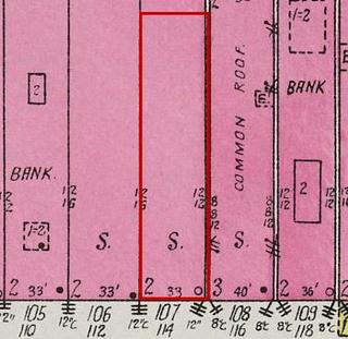
  1. 1887 Dry goods, boots and shoes map label: D.G. & B. & S. Library of Congress, sheet 1
  2. 1891 Dry goods, boots and shoes, clothing map label: D.G., B. & S., Clo. Library of Congress, sheet 3
  3. 1897 Dry goods, shoes and clothing map label: D.G., Shoes & Clo. Library of Congress, sheet 3
  4. 1902 Dry goods, shoes and clothing map label: D.G. Shoes & Clo. Library of Congress, sheet 2
  5. 1907 Dry goods, shoes and clothing map label: D.G. Shoes & Clothing Library of Congress, sheet 2
  6. 1914 Clothing and shoes map label: Clo. & Shoes Library of Congress, sheet 9
  7. 1926 Store map label: S. UT Knoxville Libraries, sheet 5

North side · College St. E.

100 College St. E.

Dry-goods corner

Today

No business is listed at this address in our directory. Know what’s here? Tell us.

On the old maps (no. 100 in 1914)

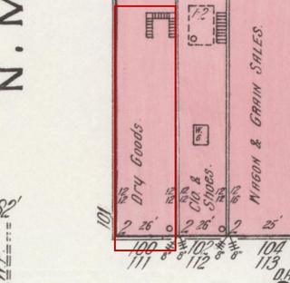
April 1914 Sanborn fire insurance map detail with the lot at today’s 100 College St. E. outlined in red; the map labels it: dry goods
Then: 1914 map
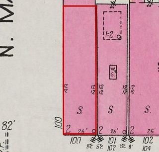
September 1926 Sanborn fire insurance map detail with the lot at today’s 100 College St. E. outlined in red; the map labels it: store
1926 map

Maps: Sanborn Map Co., April 1914, sheet 9, Library of Congress (public domain); Sept. 1926, sheet 5, UT Knoxville Libraries (No Copyright – United States). Cropped; red outline added by Our Town Almanac.
  1. 1887 Dry goods map label: D.G. Library of Congress, sheet 1
  2. 1891 Dry goods map label: D.G. Library of Congress, sheet 3
  3. 1897 Dry goods map label: D.G. Library of Congress, sheet 3
  4. 1902 Dry goods map label: D.G. Library of Congress, sheet 2
  5. 1907 Dry goods and clothing map label: D.G. & Clothing Library of Congress, sheet 2
  6. 1914 Dry goods map label: Dry Goods Library of Congress, sheet 9
  7. 1926 Store map label: S. UT Knoxville Libraries, sheet 5

Share this page: ourtownalmanac.com/tn/fayetteville/explore/square/north/

← Back to the square · Walking tour · Explore