
Get to know Fayetteville: a walk through its history
Fayetteville was laid out around its courthouse square in 1810, and much of its story is still within a few blocks of it.
14 stops2.8 mi loopabout 1 hr walking25 min of audio
This walk starts and ends on the square and visits churches, homes, cemeteries, markers and a former milk plant that is now the county museum. Every fact is attributed to a public source; where sources disagree, we show both. Go at your own pace: every time here is a suggestion.
Choose your walk
Full loop (14 stops): Stops 1, 2, 3, 4, 5, 6, 7, 8, 9, 10, 11, 12, 13, 14, then back to the square. 2.82 mi · about 61 min of walking · suggested 105–155 min at stops · total about 166–216 min (suggestion). With an inside museum visit: about 3 h 26 min to 5 h 1 min.
Shorter loop (stops 1–7): Stops 1, 2, 3, 4, 5, 6, 7, then back to the square. 1.65 mi · about 35 min of walking · suggested 60–95 min at stops · total about 95–130 min (suggestion).
If you only have 30 minutes (stops 1–4): Stops 1, 2, 3, 4, then back to the square. Quick-look times (suggestions): 5 min at the square, 10 at the lawn markers, 3 each at the Pythian Building and the Calaboose. 0.35 mi · about 8 min of walking · suggested 21–21 min at stops · total about 29–29 min (suggestion).
Start here: The Lincoln County obelisk, west side of the courthouse. Directions
Before you go: safety, respect, offline audio and check-in
Please note. Several stops are private homes or active churches: enjoy them from the public sidewalk and don’t enter yards or grounds. At the cemeteries, please be respectful: stay on paths and drives, don't touch or lean on stones, and keep voices low. We found no published visiting hours; visit in daylight and follow any posted rules. The square is ringed by U.S. 64 (College St.) and U.S. 431 (Main Ave.): use crosswalks and watch for traffic. Some stops include hard history (forced removal, slavery, the Civil War); the markers’ own words are quoted.
Download for offline: cell signal can be patchy, so you may want the tracks on your phone before you set out. Each track is a small MP3 (about 24.2 MB for all 16). See the download list.
Check in here buttons use your phone’s location once, only when you tap, to tell you when you’ve reached a stop. Your location stays on your phone; it is not sent to us or stored.
The stops
Tap a stop name to center its pin. Map data © OpenStreetMap contributors.
Audio tour
Play the whole tour 16 tracks: a welcome, one for each stop, and a closing, about 25 minutes in all.
Nothing plays until you tap. Each stop has its own Listen button with a transcript.
Welcome transcript
Welcome to Fayetteville, and thank you for walking with us. This is the Fayetteville Almanac's walk through the town's history.
You're standing on the west side of the Lincoln County Courthouse, next to a stone obelisk. That obelisk tells the town's starting story: Lincoln County was created by an act that took effect on January first, 1810, it was named for Revolutionary War General Benjamin Lincoln, and Fayetteville was built on land bought that same year from a pioneer named Ezekiel Norris. So this is a good place to begin.
The full loop has fourteen stops and is a little under three miles of walking. That's about an hour on your feet, plus whatever time you spend at each stop. If you're short on time, the first four stops make a quick loop of about half an hour. Every time we give you is only a suggestion. Go at your own pace.
A few things before we set off. Several stops are private homes. Please enjoy them from the public sidewalk, and don't step into the yards. Two stops are cemeteries, so we'll ask for quiet there. And the square sits on two busy highways, U.S. 64 and U.S. 431, so please use crosswalks and watch for traffic every time you cross.
Some of this history is hard: the forced removal of Cherokee people, slavery, and the Civil War. We'll share what the markers and sources say, plainly.
When you're ready, turn around and take a look at the square.
- Start hereHidden gemPhoto spot
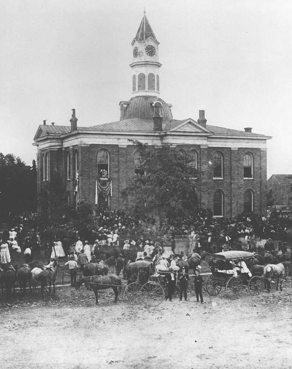
1886: a crowd at the earlier courthouse awaits the Bob Taylor–Alf Taylor debate for governor. T. V. McCown, 1886. Tennessee State Library and Archives. Public domain, via Wikimedia Commons. Transcript: Stop 1, The Courthouse Square
You're standing in the middle of the town plan. Fayetteville was laid out around this square in 1810, on land the county bought from settler Ezekiel Norris. Fayetteville Main Street, the downtown organization, writes that the acreage for the courthouse was cleared by Richard Sappington, a freed Black man. His name is worth remembering as you look around.
Main Street also points out something small that's easy to miss. On the square's northeast corner, a stone plinth marks where a survey pin was driven in 1810 to lay out the town. That's the spot Fayetteville was measured from.
The courthouse in front of you is the county's fourth. It's a Colonial Revival building from 1970. It replaced an Italianate courthouse from 1874. There's a famous photograph of that older building from 1886, with a huge crowd gathered out front waiting for the governor's race debate between two brothers, Bob Taylor and Alf Taylor.
The buildings around you have their own scars. Main Street notes that two fires in 1885 burned almost the entire west side of the square.
Today the courthouse still runs the county's business, and the storefronts hold shops, offices, and the Lincoln Theatre. Take ten minutes or so to walk the sides and look up at the upper stories.
When you're done, head onto the courthouse lawn for the monuments and markers.
Start here
Courthouse lawn, west side, at Main Ave. S. (U.S. 431) and College St. (U.S. 64). The obelisk is on the west side of the Lincoln County Courthouse (HMdb).
The obelisk tells the town's founding story (county created in 1810, town laid out on land bought from Ezekiel Norris), so the tour starts where the town's story starts. It stands next to the Main Avenue sidewalk, faces the Pythian Building (Stop 3) across the street, and is a few steps from the rest of the lawn markers (Stop 2).
Family photo at the start: Stand on the lawn a few steps from the obelisk with the courthouse and its white cupola behind your group; back up toward the Main Avenue sidewalk (stay off the street) to fit the cupola in the frame. Suggestion: this is the west side of the building, so it is lit in the afternoon; in the morning the group would be in the building's shade.
Why it matters today: Lincoln County's courthouse is still at the center, and the storefronts around it hold shops, offices and the Lincoln Theatre, all in the almanac directory.
Fayetteville was laid out around this square in 1810 on land the county bought from settler Ezekiel Norris; Fayetteville Main Street writes that the courthouse acreage was cleared by Richard Sappington, a freed Black man. Today's Colonial Revival courthouse dates from 1970 and is the county's fourth; it replaced an 1874 Italianate courthouse, seen in the 1886 photo of a crowd awaiting the Bob Taylor–Alf Taylor debate for governor. Main Street also notes that two fires in 1885 burned almost the entire west side of the square.
Hidden gem: The town's starting point is marked: a stone plinth on the square's northeast corner shows where a survey pin was driven in 1810 to lay out Fayetteville.
Photo tip: Stand on the courthouse lawn or the College Street sidewalk and face north to frame the College Street storefronts and the Lincoln Theater sign (the view in Brian Stansberry's 2015 photo). Suggestion: the north-side storefronts face south, so they are lit most of the day; late morning to mid-afternoon is easiest.
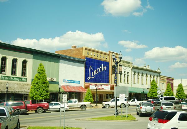
The north side of the courthouse square, College Street, with the Lincoln Theater (2015). Photo: Brian Stansberry, CC BY 3.0, via Wikimedia Commons. Nearby (from the almanac directory): Book Inn, Dragonfly Art Gallery & Design (Main Street calls this the oldest building on the west side of the square.), Lawson's Department Store, Lincoln Theatre, Whistle Stop Bakery
Sources for this stop
- Fayetteville Main Street: History of the Fayetteville Square
- Tennessee Encyclopedia: Lincoln County
- Wikipedia: Fayetteville, Tennessee
- HMdb: Lincoln County (obelisk marker)
Location: Geocoded: OpenStreetMap (Nominatim) feature 'Lincoln County Courthouse'.
- Walk 0.05 mi (about 1 min) to Courthouse Lawn: Monuments and Markers
- Hidden gemPhoto spot
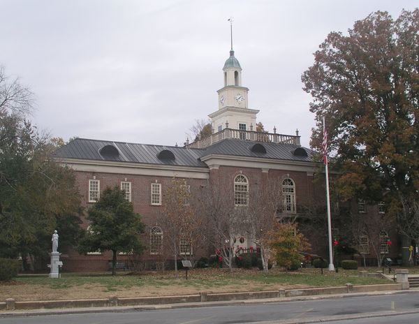
Today’s Lincoln County Courthouse, the county’s fourth, dates from 1970 (photo 2008). Photo: Ichabod, CC BY-SA 3.0, via Wikimedia Commons (resized). Transcript: Stop 2, Courthouse Lawn: Monuments and Markers
You're on the courthouse lawn, and you're surrounded by more than a century of people deciding what to remember. The markers here were placed between 1904 and 2018, and each one says who put it up.
The Tennessee Civil War Trails marker says Lincoln County sent almost five thousand men to the Confederate army. Union troops held the town from the spring of 1863 to the end of the war, and they used the walled courthouse as a stable and a temporary fort. In November 1863, Sherman's army crossed the Elk River on the stone bridge south of town.
Another marker records Bell's Route of the Trail of Tears. In late October and early November of 1838, a group of Cherokee people, escorted by Lieutenant Edward Deas, passed through Fayetteville on the forced journey west. The marker says many who began that journey died along the way.
A stone titled "Martyred," first placed by the United Daughters of the Confederacy in 1914, records that on June 15, 1864, three local men were executed without trial on the order of Union General E. A. Paine.
At the northeast corner is the Confederate Monument. The United Daughters of the Confederacy unveiled it in 1906, according to its marker; a Smithsonian survey lists 1904. In front of it are two cannons with a surprising story: they were cast in Reading, Pennsylvania, in 1865 and 1866, guarded Fort Morgan, Alabama, during the Spanish-American War, and came here in 1905.
Look too for the 1957 War Memorial, the horse mounting stones, and the Revolutionary War Patriots Memorial from 2018.
Why it matters today: Each marker names who placed it and when, so the lawn reads like a timeline of how the town has marked its past.
The courthouse grounds hold markers and memorials placed between 1904 and 2018. The Tennessee Civil War Trails marker says Lincoln County furnished almost 5,000 Confederate soldiers and that Union troops, who held the town from spring 1863 to the end of the war, used the walled courthouse as a stable and temporary fort. Other markers record the 1838 forced removal of Cherokee people along Bell's Route through Fayetteville, and the execution without trial of three local men on Union Gen. E. A. Paine's order in June 1864.
What to look for on the lawn (14 markers and memorials)
- Lincoln County (obelisk, west side): Says the county was created by an 1809 act effective January 1, 1810, named for Revolutionary War Gen. Benjamin Lincoln, and that Fayetteville was built on land bought in 1810 from pioneer Ezekiel Norris. Source
- Lincoln County in the Civil War (Tennessee Civil War Trails): Federal forces entered in April 1862, withdrew, and returned the next spring until the war's end; Sherman's army crossed the Elk River on the stone bridge in November 1863. Source
- Bell's Route Trail of Tears: In late October and early November 1838, a group of Cherokee people escorted by Lt. Edward Deas passed through Lincoln County and Fayetteville on the way to Oklahoma; the marker says many who began the journey died along the trail. Source
- Martyred (original marker erected June 15, 1914, by the U.D.C.): Records that on June 15, 1864, John Massey, William Pickett and Frank Burroughs were executed without trial on Union Gen. E. A. Paine's order, two blocks north of here, where the stone was first placed. John Massey had offered himself in place of his younger brother. Source
- Confederate Monument and Confederate Park (northeast corner): The United Daughters of the Confederacy's Zollicoffer-Fulton Chapter unveiled the monument on September 6, 1906, per its marker; the Smithsonian's outdoor sculpture survey lists it as dedicated in 1904. The statue was made in Carrara, Italy. Source
- Confederate Park cannons: Cast by the Scott Foundry of Reading, Pennsylvania, in January 1865 and February 1866; mounted at Fort Morgan, Alabama, in 1898 for Spanish-American War coastal defense; installed here in 1905. Source
- Confederate Soldiers stone (U.D.C.): Its inscription remembers 'the three thousand Confederate soldiers of Lincoln County.' (The Civil War Trails marker gives almost 5,000.) Source
- Women of the Confederacy fountain (1904, U.D.C.): A fountain near the southwest corner, erected by the Zollicoffer-Fulton Chapter. Source
- War Memorial for Lincoln County and City of Fayetteville (erected Oct. 7, 1957): Lists local service members who died in World War I, World War II, Korea and Vietnam, with a later name from Operation Iraqi Freedom; sponsored by the American Legion and the VFW. Source
- Revolutionary War Patriots Memorial (2018, Kings Mountain Messenger Chapter NSDAR): Lists Revolutionary War patriots who settled in Lincoln County; dated 1775–1783. Source
- King's Mountain Messenger (D.A.R.): Says Joseph Greer carried news of the 1780 victory at King's Mountain to the Continental Congress in Philadelphia. Source
- Horse Mounting Stones (plaque, 1980): Stones early settlers used to climb onto their horses, moved here from North Franklin Avenue. Source
- Robert E. Lee School and James Moores Home bricks (2010): Historic bricks from a school (circa 1900) and a home (circa 1917), placed in a 2010 Fayetteville Main Street project. Source
- Tulip poplar for James Taylor Crawford: Tennessee's state tree, planted in memory of a state representative, state senator and county judge (1903–1977). Source
Hidden gem: The 'Confederate Park' cannons were cast in Pennsylvania in 1865–66 and guarded Fort Morgan, Alabama, in the Spanish-American War before coming here in 1905.
Photo tip: From the College Street sidewalk at the northeast corner, frame the statue with the two cannons in front of it. Suggestion: the statue faces north (per its marker), so its front is in shade much of the day; overcast light, or early morning and late afternoon in summer, works best.
Sources for this stop
- HMdb: Lincoln County in the Civil War
- HMdb: Bell's Route Trail of Tears
- HMdb: Martyred
- HMdb: Confederate Park
- HMdb: Confederate Park Cannon
- HMdb: Confederate Soldiers
- HMdb: Women of the Confederacy
- HMdb: War Memorial for Lincoln County and City of Fayetteville
- HMdb: Revolutionary War Patriots Memorial
- HMdb: King's Mountain Messenger
- HMdb: Horse Mounting Stones
- HMdb: Robert E. Lee School and The James Moores Home
- HMdb: In Memory of James Taylor Crawford
- HMdb: Lincoln County
- Smithsonian (Save Outdoor Sculpture!): Confederate Monument, Fayetteville
Location: HMdb: 'Lincoln County in the Civil War' marker (35° 9.102′ N, 86° 34.164′ W).
- Walk 0.11 mi (about 2 min) to The Pythian Building
- Hidden gemPhoto spot
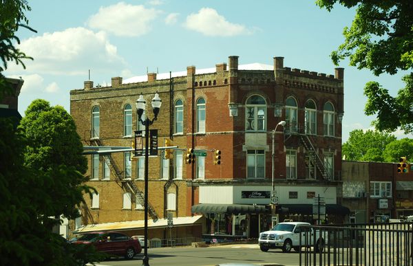
The Pythian Building, built about 1900 by the Knights of Pythias. Photo: Brian Stansberry, CC BY 3.0, via Wikimedia Commons. Transcript: Stop 3, The Pythian Building
Look across Main Avenue at the three-story brick building on the corner, with the arched windows up top. Please use the crosswalk if you'd like a closer look; this is U.S. 431, and traffic moves.
This is the Pythian Building. It was built around 1900 by the Knights of Pythias, a fraternal order. The lodge met in the hall on the top floor, and the lower floors held shops and offices.
Here's the part Fayetteville Main Street likes to tell. This building also held the town's first public library. And it was founded and run for more than half a century, without any public money, by a women's literary club called the Round Dozen. For more than fifty years, if you wanted to borrow a book in Fayetteville, you had a group of local women to thank.
Today the building still anchors this corner of the square, and the Fayetteville Main Street office is inside, in Suite 1A. They keep weekday office hours, so if you have questions about downtown, it's a good place to ask.
If you're taking photos, the building faces east, so morning light is kindest to the brick.
Our next stop is just around the corner, on West Market Street: a jail that now serves lunch.
Why it matters today: It still anchors the square's northwest corner, and the downtown Fayetteville Main Street office is in the building.
Built around 1900 by the Knights of Pythias, a fraternal order, this three-story brick building had the lodge's meeting hall on the top floor and shops and offices below. Fayetteville Main Street writes that it also held Fayetteville's first 'public library,' founded and run for more than half a century, without public funds, by a women's literary club called the Round Dozen.
Hidden gem: For over 50 years a women's club ran the town's library here with no public money.
Photo tip: From the courthouse lawn's northwest corner, shoot across Main Avenue to get the corner and the arched upper windows. Suggestion: the building is on the west side of the square facing east, so morning light is best.
Nearby (from the almanac directory): Main Street Grill
Sources for this stop
- Fayetteville Main Street: History (The Pythian Building)
- Wikimedia Commons: Pythian Building file description
Location: Geocoded from the address: OpenStreetMap (Nominatim).
- Walk 0.09 mi (about 2 min) to The Old City Calaboose (1867 town jail)
- Hidden gem
Transcript: Stop 4, The Old City Calaboose (1867 town jail)
You're on West Market Street, just off the square. The building at 114 West Market has a past you'd never guess from the sidewalk.
"Calaboose" is an old word for a jail. A marker at Stone Bridge Memorial Park, south of town, says the old city calaboose, Fayetteville's town jail, was built in 1867, and that Cahoots Restaurant is in the building today. So a building that once held prisoners now serves meals.
The jail's barred door didn't stay here. It was moved to Stone Bridge Memorial Park, where it's on display with a plaque. The plaque reads, quote, "Many a person has looked through these bars." If you drive out to the park later, it's worth finding.
The restaurant is a business, so enjoy the outside anytime, and go in only as a customer during business hours.
If you're on the short version of the tour, this is where you turn back. The square is a couple of minutes away, and you've covered about a third of a mile.
If you're doing the full loop, our next stop is a longer walk west along College Street, about half a mile, to one of the oldest congregations in town. Stay on the sidewalk, and take care at the crossings.
Why it matters today: A building that once held prisoners now serves meals a block off the square.
A marker at Stone Bridge Memorial Park says the old city calaboose, the town jail, was built in 1867 and that Cahoots Restaurant is in the building today; the almanac directory lists the restaurant at 114 W. Market St. The jail's barred door was moved to the park, where its plaque reads: 'Many a person has looked through these bars.'
Hidden gem: Lunch in the old jail: the 1867 calaboose is a restaurant now, and its barred door is on display at Stone Bridge Memorial Park.
Nearby (from the almanac directory): Cahoots Restaurant
Sources for this stop
Location: Geocoded from the directory address: OpenStreetMap (Nominatim).
- Walk 0.46 mi (about 10 min) to St. Paul A.M.E. Church
- Hidden gemPhoto spotActive church: view from the sidewalk
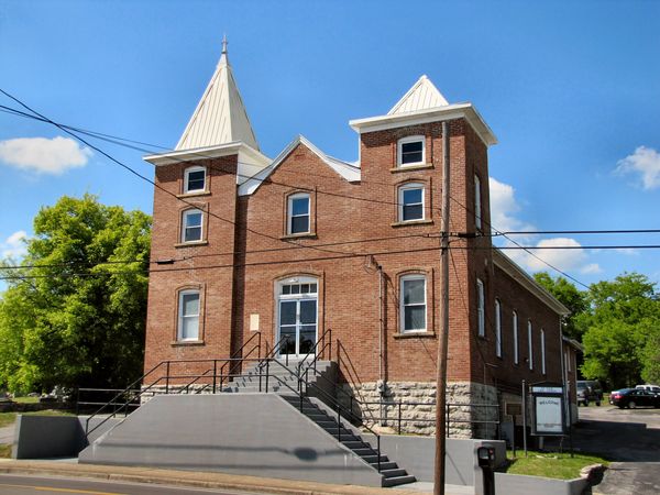
St. Paul A.M.E. Church. Photo: Brian Stansberry, CC BY 3.0, via Wikimedia Commons. Transcript: Stop 5, St. Paul A.M.E. Church
You're on West College Street, looking at a red brick church with two square towers and white spires. This is St. Paul A.M.E. Church, and its congregation goes back to 1824. It's an active church, so please enjoy it from the sidewalk and stay off the steps and grounds.
The congregation began as what was called the "African Church." A 2013 article in the Elk Valley Times says it was probably organized by white slaveholders for the enslaved people in their households. That beginning is part of the church's story.
In 1867, two years after the Civil War ended, the congregation moved to this site. The brick church you see was finished in 1913. Oral histories cited in that same article say the women of the church carried the bricks to the site in their aprons.
On October 3, 2003, St. Paul was listed on the National Register of Historic Places, after research by Middle Tennessee State University. You'll find a National Register plaque at the corner of College and Edison Streets.
The church appears to face south, so it should be lit from late morning through mid-afternoon if you'd like a photo from across the street.
Next, we'll walk a short way to Rose Hill Cemetery.
Why it matters today: An active congregation, and one of two Fayetteville churches on the National Register under the state study of historic African American churches.
The congregation began in 1824 as the 'African Church,' which a 2013 Elk Valley Times article says was probably organized by white slaveholders for enslaved people in their households; it moved to this West College Street site in 1867. The brick church was completed in 1913, and oral histories cited in the same article say the women of the church carried bricks to the site in their aprons. It was listed on the National Register on October 3, 2003, after research by Middle Tennessee State University.
Hidden gem: Oral histories say the women of the church carried its bricks to the site in their aprons.
Photo tip: From the sidewalk across College Street, frame both square towers and their white spires. Suggestion: the church is on the north side of College Street facing south (inferred from the plaque's location), so it is lit from late morning through mid-afternoon.
Active church: view from the sidewalk. Inside only by arrangement with the congregation.
Nearby (from the almanac directory): St Paul Ame Church
Sources for this stop
- Wikipedia: St. Paul African Methodist Episcopal Church (Fayetteville, Tennessee)
- HMdb: St. Paul AME Church plaque
- Wikipedia NRHP list, Lincoln County
- NPS NRHP record 03001003
Location: HMdb: National Register plaque at College St. W. and Edison St. (35° 9.19′ N, 86° 34.66′ W).
- Walk 0.12 mi (about 2 min) to Rose Hill Cemetery
- Hidden gemCemetery: please be respectful
Transcript: Stop 6, Rose Hill Cemetery
You've arrived at Rose Hill Cemetery. Before you go in, a gentle request: this is a place of rest, and families still visit. Please stay on the paths and drives, don't touch or lean on the stones, and keep your voice low. We didn't find published visiting hours, so please come in daylight and follow any posted rules.
Rose Hill is a large town cemetery. Find a Grave lists more than fifty-five hundred memorials here.
Two of the people buried here show how far Fayetteville's story reaches. George Washington Jones, who lived from 1806 to 1884, served in the U.S. Congress from 1843 to 1859, and later in the Confederate Congress. The Political Graveyard, a reference on American politicians, records that he was a slaveholder.
And Admiral Frank B. Kelso the Second, who lived from 1933 to 2013, was a Fayetteville native who rose to become the Navy's Chief of Naval Operations, the Navy's top officer. He came home to rest in his hometown.
In October 2023, Fayetteville Main Street held a self-guided history stroll here, with costumed actors telling the stories of people buried on these grounds.
Take fifteen minutes or more if you'd like to walk quietly through the older sections. When you're ready, our next stop is about half a mile away, back toward the south side of town, at Mount Zion Missionary Baptist Church.
Why it matters today: Fayetteville Main Street has used it for a self-guided history stroll with costumed actors (October 2023).
Rose Hill is a large town cemetery on College Street West; Find a Grave lists more than 5,500 memorials there. Burials include George Washington Jones (1806–1884), a U.S. congressman from 1843 to 1859 and later a member of the Confederate Congress, whom the Political Graveyard records as a slaveholder, and Adm. Frank B. Kelso II (1933–2013), a Fayetteville native who served as the Navy's Chief of Naval Operations.
Hidden gem: The admiral who served as the Navy's Chief of Naval Operations is buried in his hometown.
Please be respectful: stay on paths and drives, don't touch or lean on stones, and keep voices low. We found no published visiting hours; visit in daylight and follow any posted rules.
Sources for this stop
- Find a Grave: Rose Hill Cemetery
- Find a Grave: Famous memorials in Rose Hill Cemetery
- The Political Graveyard: Lincoln County, Tenn.
- Fayetteville Main Street: Rose Hill Cemetery Stroll (Oct. 21, 2023)
- Wikipedia: Borden Milk Plant (Kelso a Fayetteville native)
Location: Find a Grave cemetery 17955 coordinates.
- Walk 0.46 mi (about 10 min) to Mount Zion Missionary Baptist Church
- Hidden gemPhoto spotActive church: view from the sidewalk
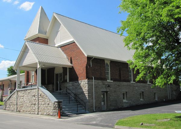
Mount Zion Missionary Baptist Church. Photo: Brian Stansberry, CC BY 3.0, via Wikimedia Commons. Transcript: Stop 7, Mount Zion Missionary Baptist Church
You're on West Maple Street, at Mount Zion Missionary Baptist Church. It's an active church, so please enjoy it from the sidewalk.
Mount Zion's story begins in 1873. According to the church's history, it was organized by formerly enslaved people and the sons of enslaved people, who bought land for a church that same year.
An earlier building burned. The two-story brick and stone building in front of you, in the Gothic Revival style, with its steep gable, dates from 1902.
Mount Zion also has a place in the civil rights story. The National Register study of African American churches notes that it hosted the Lincoln County organizational meetings of the NAACP.
It was listed on the National Register of Historic Places on July 6, 2000. Together with St. Paul, which you just visited, it's one of two Fayetteville churches recognized in the state's study of historic African American churches.
If you're on the shorter loop, this is your turnaround point; head back to the square, about a third of a mile. If you're on the full loop, we're heading about a third of a mile south, to an old milk plant that's now the county museum.
Why it matters today: The church organized in 1873 still stands on West Maple Street and is one of two Fayetteville churches recognized in the state's study of historic African American churches.
Mount Zion was organized in 1873 by formerly enslaved people and the sons of enslaved people, who bought land for a church that year, according to the church's history. The present two-story brick and stone Gothic Revival building dates from 1902, after an earlier building burned, and the National Register study of African American churches notes that it hosted Lincoln County organizational meetings of the NAACP. It was listed on the National Register on July 6, 2000.
Hidden gem: This church hosted Lincoln County's NAACP organizing meetings.
Photo tip: From the Maple Street sidewalk, the steep gable and stone foundation photograph well straight on. Facing direction not confirmed; soft overcast light avoids harsh shadows on the brick.
Active church: view from the sidewalk. Inside only by arrangement with the congregation.
Sources for this stop
- Wikipedia: Mount Zion Missionary Baptist Church (Fayetteville, Tennessee)
- Wikipedia NRHP list, Lincoln County
- NPS NRHP record 00000731
Location: Wikipedia NRHP list and article infobox (35° 9′ 0″ N, 86° 34′ 26″ W; low precision).
- Walk 0.33 mi (about 7 min) to Fayetteville-Lincoln County Museum (Borden Milk Plant)
- Hidden gemPhoto spot
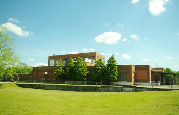
The 1927 Borden Powdered Milk Plant, now the Fayetteville-Lincoln County Museum (NRHP). Photo: Brian Stansberry, CC BY 3.0, via Wikimedia Commons. Transcript: Stop 8, Fayetteville-Lincoln County Museum (Borden Milk Plant)
You're on Main Avenue South, in front of a long, low brick building. In 1927, the Borden company built this plant to turn local milk into butter and powdered milk.
It mattered to a lot of families. At its peak, the plant had seventy-five employees and bought milk from more than twelve hundred farmers. During World War Two, it dried milk and eggs for the U.S. military.
The museum says the plant closed on December 15, 1967. The Tennessee Encyclopedia gives 1962, so the sources don't quite agree. The building was listed on the National Register in 1988, and today it's home to the Fayetteville-Lincoln County Museum, with thirty-three thousand square feet of space. If it's open, you could easily spend an hour inside. Check the museum's website for current hours.
Now, out front, look for a Tennessee Music Pathways marker. It honors Ed Townsend, a songwriter and producer born in Fayetteville in 1929. Townsend co-wrote and co-produced half of Marvin Gaye's 1973 album, "Let's Get It On."
Next, we'll head east to South Elk Avenue, where the walk turns residential. The next stops are private homes, so please enjoy them from the sidewalk.
Why it matters today: The plant the museum credits with helping the county through the Great Depression now houses Lincoln County's volunteer-run community museum.
Borden built this plant in 1927 to turn local milk into butter and powdered milk; at its peak it had 75 employees and bought milk from more than 1,200 farmers, and during World War II it dried milk and eggs for the U.S. military. The museum says the plant closed on December 15, 1967 (the Tennessee Encyclopedia gives 1962). Listed on the National Register in 1988, it now houses the Fayetteville-Lincoln County Museum; out front, a Tennessee Music Pathways marker honors Fayetteville-born songwriter and producer Ed Townsend (born 1929).
Hidden gem: The marker out front: Fayetteville-born Ed Townsend co-wrote and co-produced half of Marvin Gaye's 1973 album 'Let's Get It On.'
Photo tip: From the Main Avenue South sidewalk, take the long, low brick plant from a front corner to show its length. Facing direction not confirmed; overcast or late-day light suits the long brick front.
Nearby (from the almanac directory): Fayetteville-Lincoln County Museum & Event Center (Borden Milk Plant)
Sources for this stop
- Fayetteville-Lincoln County Museum: About
- Wikipedia: Borden Milk Plant
- Tennessee Encyclopedia: Lincoln County
- HMdb: Birthplace of Ed Townsend (Tennessee Music Pathways)
- NPS NRHP record 88001060
Location: HMdb: 'Birthplace of Ed Townsend' marker in front of the museum (35° 8.835′ N, 86° 34.3′ W).
- Walk 0.25 mi (about 5 min) to McDonald-Bolner House
- Photo spotPrivate: view from the sidewalk
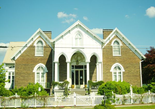
McDonald-Bolner House. Photo: Brian Stansberry, CC BY 3.0, via Wikimedia Commons. Transcript: Stop 9, McDonald-Bolner House
You're on South Elk Avenue. The house at 400 South Elk is a private home, so please stay on the public sidewalk, don't step into the yard, and keep the group moving so the people who live here have their peace.
This is the McDonald-Bolner House. According to its National Register nomination, it was built in 1859 for a cotton farmer and his wife. Its design is Gothic Revival; look for the steep, pointed gables.
The house was listed on the National Register of Historic Places on May 31, 1984. It's one of the few houses within walking distance of the square that's listed on its own, not just as part of a district.
If you'd like a photo, a zoom lets you frame the gables over the fence without stepping onto the property. The house appears to face west, so afternoon light is likely best, but that's only a suggestion.
Our next stop is right here on the same street, just a few steps away: the South Elk Street Historic District.
Why it matters today: One of the few individually listed National Register houses within walking distance of the square.
Built in 1859 for a cotton farmer and his wife, this house is designed in the Gothic Revival style, according to its National Register nomination. It was listed on the National Register on May 31, 1984.
Photo tip: Public sidewalk only. A zoom lets you frame the pointed gables over the picket fence without stepping onto the property. Suggestion (facing unverified): even-numbered houses on this block of Elk Ave. S. appear to be on the east side facing west, so afternoon light.
Private residence: view from the public sidewalk only.
Sources for this stop
Location: Wikipedia article infobox (35° 08′ 57″ N, 86° 34′ 10″ W).
- Walk 0.03 mi (about 1 min) to South Elk Street Historic District
- Hidden gemPhoto spotPrivate homes: sidewalk only
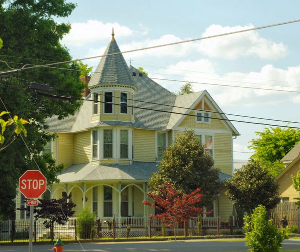
In the South Elk Street Historic District. Photo: Brian Stansberry, CC BY 3.0, via Wikimedia Commons. Transcript: Stop 10, South Elk Street Historic District
You're in the South Elk Street Historic District. These are private homes, so please enjoy them from the public sidewalk only.
The district was listed on the National Register in 1989. It runs roughly along South Elk Street, between East Campbell Street, Franklin Street, and the old L and N railroad tracks.
Near the north end of the district, on the east side of the street, look for two houses with National Register plaques, at 304 and 310 Elk Avenue South. Here's the one to look for: the plaque at 310 dates that house to 1827. Fayetteville was laid out in 1810, so that house went up just seventeen years after the town itself.
The district also includes the yellow Queen Anne house with the corner turret and porch, from the 1880s.
Take five or ten minutes to stroll a block and read the plaques from the sidewalk. These houses face west, so afternoon light is a good suggestion for photos.
When you're ready, we'll head northeast, back past the square, to the town's early burial ground, the Old City Cemetery. The walk is about a third of a mile. Watch for traffic as you cross near the square.
Why it matters today: A residential street where plaques mark some of the oldest houses close to the square.
Listed on the National Register in 1989, the district runs roughly along South Elk Street between East Campbell Street, Franklin Street and the former L&N railroad tracks. Near its north end, houses at 304 and 310 Elk Ave. S. carry National Register plaques, and the plaque at 310 dates that house to 1827. The district also includes the 1880s Queen Anne house in the photo.
Hidden gem: A plaque dates 310 Elk Ave. S. to 1827, just 17 years after the town was laid out.
Photo tip: Public sidewalk only: the yellow Queen Anne house with its corner turret is the classic shot. Suggestion: the plaqued houses are on the east side of Elk Ave. S. facing west (per HMdb location notes), so afternoon light.
Private residences: view from the public sidewalk only.
Sources for this stop
- Wikipedia NRHP list, Lincoln County (district boundaries, 1989)
- HMdb: plaque at 310 Elk Ave. S.
- HMdb: plaque at 304 Elk Ave. S.
- Wikimedia Commons: Queen Anne house in the district (1880s)
- NPS NRHP record 89000127
Location: HMdb: plaque at Elk Ave. S. and Maple St. E. (35° 8.98′ N, 86° 34.166′ W).
- Walk 0.3 mi (about 6 min) to Old City Cemetery
- Hidden gemPhoto spotCemetery: please be respectful
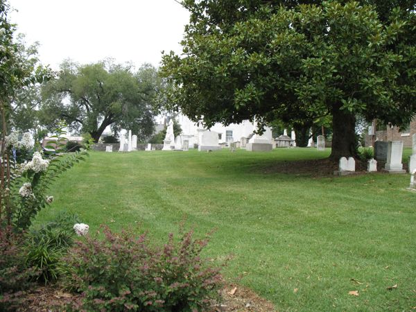
The Old City Cemetery, a block east of the square (2006). Photo: Natalie Maynor, CC BY 2.0, via Wikimedia Commons (from Flickr; resized). Transcript: Stop 11, Old City Cemetery
You're at the corner of Mulberry Avenue and Column Street, at the Old City Cemetery. It's only a block from the square, and it's easy to walk right past. Please be respectful here: stay on the paths, don't touch or lean on the stones, and keep voices low. We found no published visiting hours, so please come in daylight and follow any posted rules.
Find a Grave lists this as the Old Fayetteville City Cemetery. It's also known as the First Presbyterian Church Cemetery, and it holds about two hundred fifty memorials.
Fayetteville Main Street writes that the land came from James Bright, an early citizen who served as Surveyor General of Tennessee. He gave ground for the Presbyterian church and for the town's burial ground, and the church is right next door; that's our next stop.
Among those buried here is John Morgan Bright, who lived from 1817 to 1911 and served in the U.S. Congress from 1871 to 1881. The Political Graveyard records that he was a slaveholder.
Notice the old stones under the big magnolia and the other large trees. If you'd like a photo, the trees cast deep shade at midday, so an overcast day or early morning gives the most even light. Please take photos from the paths.
Take ten minutes or so to read a few of the older stones. Then walk a few steps to the brick church next door.
Why it matters today: An easy-to-miss green space a block from the square, kept as a burial ground since the town's early years.
Find a Grave lists this burial ground as the Old Fayetteville City Cemetery, also known as the First Presbyterian Church Cemetery, with about 250 memorials. Fayetteville Main Street writes that early citizen James Bright, Surveyor General of Tennessee, gave land for the Presbyterian church and the town burial ground. Burials include John Morgan Bright (1817–1911), a U.S. congressman from 1871 to 1881, whom the Political Graveyard records as a slaveholder.
Hidden gem: Fayetteville's early town burial ground is a block off the square and easy to walk past.
Photo tip: Old stones under a big magnolia and other large trees; shoot from the paths, as in Natalie Maynor's 2006 photo. Suggestion: the big trees cast deep shade at midday; overcast days or early morning give even light on the stones.
Please be respectful: stay on paths and drives, don't touch or lean on stones, and keep voices low. We found no published visiting hours; visit in daylight and follow any posted rules.
Sources for this stop
- Find a Grave: Old Fayetteville City Cemetery
- Fayetteville Main Street: History (First Presbyterian Church)
- The Political Graveyard: Lincoln County, Tenn.
- WikiTree: Old Fayetteville City Cemetery (location)
Location: Find a Grave cemetery 16579 coordinates.
- Walk 0.07 mi (about 2 min) to First Presbyterian Church
- Hidden gemPhoto spotActive church: view from the sidewalk
Transcript: Stop 12, First Presbyterian Church
You're at 101 Mulberry Avenue, First Presbyterian Church. It's an active congregation, so please enjoy it from the sidewalk.
The church says its congregation was organized in the fall of 1812; Fayetteville Main Street gives 1814. Either way, it's nearly as old as the town, and its first members met in the log courthouse.
In 1832, they built a church on this site. On February 24, 1851, a storm destroyed it. The church clerk at the time, John Morgan Bright, whose grave you may have just passed next door, wrote in the records that "our church was crushed to its foundations."
The building you see was raised from bricks burned right here on the spot, and it was dedicated on September 17, 1854. Fayetteville Main Street calls it the oldest public structure in Lincoln County.
During the Civil War, the church writes, oral tradition says the Union Army used the upstairs as a hospital and the basement as a stable. Main Street adds a story about the steeple: members tried to pull the war-damaged steeple down with oxen, mules, and horses. It held, until they'd loosened it so much it had to come down.
The four columns out front date from 1917, when the front was extended.
Next, we'll walk north into the Mulberry-Washington-Lincoln Historic District. Those are private homes, so we'll stay on the sidewalk.
Why it matters today: An active congregation (in the almanac directory) still worshipping in its 1854 building.
The congregation was organized in 1812, according to the church (Fayetteville Main Street gives 1814), and first met in the log courthouse. After a storm destroyed its 1832 building on February 24, 1851, the present church was built of bricks burned on the spot and dedicated on September 17, 1854; Main Street calls it the oldest public structure in Lincoln County. The church writes that oral tradition holds the Union Army used the upstairs as a hospital and the basement as a stable during the occupation.
Hidden gem: Main Street says members tried to pull down the war-damaged steeple with oxen, mules and horses; it held until they loosened it so much it had to come down.
Photo tip: From the Mulberry Avenue sidewalk, take the columned front straight on (its four columns date from a 1917 extension, per the church). Facing direction not confirmed; check the sun before you go.
Active church: view from the sidewalk. Inside only by arrangement with the congregation.
Nearby (from the almanac directory): First Presbyterian Church
Sources for this stop
- First Presbyterian Church Fayetteville: Our History
- Fayetteville Main Street: History (First Presbyterian Church)
Location: Geocoded from the address: OpenStreetMap (Nominatim).
- Walk 0.13 mi (about 3 min) to Mulberry-Washington-Lincoln Historic District
- Photo spotPrivate homes: sidewalk only
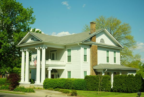
In the Mulberry-Washington-Lincoln Historic District. Photo: Brian Stansberry, CC BY 3.0, via Wikimedia Commons. Transcript: Stop 13, Mulberry-Washington-Lincoln Historic District
You're on Mulberry Avenue, near Washington Street, in the Mulberry-Washington-Lincoln Historic District. These are private homes, so please stay on the public sidewalk and don't step into the yards.
The district was listed on the National Register of Historic Places in 1984. It covers parts of Bright, Elk, Green, Main, Lincoln, Mulberry, and Washington Streets, the older residential streets close to the square. People still live here.
Fayetteville Main Street's history notes point out something you can look for. From the corner of Washington Street and Main Avenue, you can see three of the town's few remaining antebellum houses, meaning houses built before the Civil War.
One house in the district, the white house with the columned front porch in our photo, was built around 1850 and remodeled in the 1920s.
Take ten minutes or so to stroll the sidewalks under the shade trees. Soft morning or late-afternoon light is nice here for photos, but that's only a suggestion.
Our next stop is a short walk west, on Elk Avenue North: one of the most elaborate Victorian houses near the square.
Why it matters today: The town's older residential streets near the square, still lived in today.
Listed on the National Register in 1984, this residential district covers parts of Bright, Elk, Green, Main, Lincoln, Mulberry and Washington streets. Fayetteville Main Street's history notes say three of the town's few remaining antebellum houses can be seen from the corner of Washington Street and Main Avenue. The pictured house in the district was built about 1850 and remodeled in the 1920s.
Photo tip: Public sidewalks only: columned porches and big shade trees along Mulberry Avenue. Suggestion: tree-lined streets look best in soft morning or late-afternoon light.
Private residences: view from the public sidewalk only.
Nearby (from the almanac directory): Fayetteville-Lincoln County Public Library
Sources for this stop
- Wikipedia NRHP list, Lincoln County (district description)
- Fayetteville Main Street: History (Washington and Main)
- Wikimedia Commons: house in the district (c. 1850, remodeled 1920s)
- NPS NRHP record 84003580
Location: Geocoded intersection of two streets named in the NRHP district description: OpenStreetMap (Overpass).
- Walk 0.24 mi (about 5 min) to Hugh Bright Douglas House
- Photo spotPrivate: view from the sidewalk
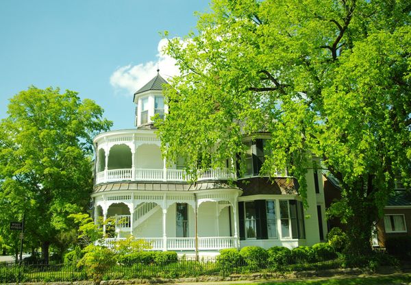
Hugh Bright Douglas House. Photo: Brian Stansberry, CC BY 3.0, via Wikimedia Commons. Transcript: Stop 14, Hugh Bright Douglas House
You're on Elk Avenue North, near Washington Street. The white Victorian house at 301 Elk Avenue North, with the wraparound porch and the turret, is a private home. Please enjoy it from the public sidewalk and keep the group off the yard.
This is the Hugh Bright Douglas House. It was built in 1894 for its namesake. The plaque out front says circa 1893, so the sources differ by a year. Hugh Bright Douglas was a Confederate veteran who served under Generals Nathan Bedford Forrest and Joseph Wheeler.
The house was designed by the firm Rickman and Bills in a style sometimes called "Steamboat Gothic."
Fayetteville Main Street shares a detail you can't see from out here. The elaborate woodwork inside, the millwork, was made from lumber cut on the family's fourteen-hundred-acre farm east of town. So part of the countryside around Fayetteville is built into this house.
It was listed on the National Register of Historic Places on March 25, 1982. The house faces west, so afternoon light is the suggestion for a photo.
This is our last stop. The square is just a few minutes' walk south from here, down Elk Avenue. Please use the crosswalks as you come back onto the square.
Why it matters today: One of the most elaborate Victorian houses near the square, listed on the National Register.
Built in 1894 for its namesake, a Confederate veteran who served under Generals Nathan Bedford Forrest and Joseph Wheeler, this house was designed by Rickman & Bills in the 'Steamboat Gothic' style (the plaque out front says circa 1893). Fayetteville Main Street writes that its elaborate interior millwork was made from lumber felled on the family's 1,400-acre farm east of town. It was listed on the National Register on March 25, 1982.
Photo tip: From the public sidewalk at Washington Street, frame the wraparound porch and turret through the trees. Suggestion: the house is on the east side of Elk Ave. N. facing west (per HMdb location notes), so afternoon light.
Private residence: view from the public sidewalk only.
Sources for this stop
- Wikipedia: Hugh Bright Douglas House
- HMdb: plaque at 301 Elk Ave. N.
- Fayetteville Main Street: History (The Douglas House)
- NPS NRHP record 82003986
Location: Geocoded from the address: OpenStreetMap (Nominatim); matches the HMdb plaque location.
- Walk 0.19 mi (about 4 min) to Back to the Courthouse Square


Best photo spots
All from public sidewalks or paths. Light notes are suggestions.
- 1. The Courthouse Square: Stand on the courthouse lawn or the College Street sidewalk and face north to frame the College Street storefronts and the Lincoln Theater sign (the view in Brian Stansberry's 2015 photo). Suggestion: the north-side storefronts face south, so they are lit most of the day; late morning to mid-afternoon is easiest.
- 2. Courthouse Lawn: Monuments and Markers: From the College Street sidewalk at the northeast corner, frame the statue with the two cannons in front of it. Suggestion: the statue faces north (per its marker), so its front is in shade much of the day; overcast light, or early morning and late afternoon in summer, works best.
- 3. The Pythian Building: From the courthouse lawn's northwest corner, shoot across Main Avenue to get the corner and the arched upper windows. Suggestion: the building is on the west side of the square facing east, so morning light is best.
- 5. St. Paul A.M.E. Church: From the sidewalk across College Street, frame both square towers and their white spires. Suggestion: the church is on the north side of College Street facing south (inferred from the plaque's location), so it is lit from late morning through mid-afternoon.
- 7. Mount Zion Missionary Baptist Church: From the Maple Street sidewalk, the steep gable and stone foundation photograph well straight on. Facing direction not confirmed; soft overcast light avoids harsh shadows on the brick.
- 8. Fayetteville-Lincoln County Museum (Borden Milk Plant): From the Main Avenue South sidewalk, take the long, low brick plant from a front corner to show its length. Facing direction not confirmed; overcast or late-day light suits the long brick front.
- 9. McDonald-Bolner House: Public sidewalk only. A zoom lets you frame the pointed gables over the picket fence without stepping onto the property. Suggestion (facing unverified): even-numbered houses on this block of Elk Ave. S. appear to be on the east side facing west, so afternoon light.
- 10. South Elk Street Historic District: Public sidewalk only: the yellow Queen Anne house with its corner turret is the classic shot. Suggestion: the plaqued houses are on the east side of Elk Ave. S. facing west (per HMdb location notes), so afternoon light.
- 11. Old City Cemetery: Old stones under a big magnolia and other large trees; shoot from the paths, as in Natalie Maynor's 2006 photo. Suggestion: the big trees cast deep shade at midday; overcast days or early morning give even light on the stones.
- 12. First Presbyterian Church: From the Mulberry Avenue sidewalk, take the columned front straight on (its four columns date from a 1917 extension, per the church). Facing direction not confirmed; check the sun before you go.
- 13. Mulberry-Washington-Lincoln Historic District: Public sidewalks only: columned porches and big shade trees along Mulberry Avenue. Suggestion: tree-lined streets look best in soft morning or late-afternoon light.
- 14. Hugh Bright Douglas House: From the public sidewalk at Washington Street, frame the wraparound porch and turret through the trees. Suggestion: the house is on the east side of Elk Ave. N. facing west (per HMdb location notes), so afternoon light.
- Family photo at the start: Stand on the lawn a few steps from the obelisk with the courthouse and its white cupola behind your group; back up toward the Main Avenue sidewalk (stay off the street) to fit the cupola in the frame. Suggestion: this is the west side of the building, so it is lit in the afternoon; in the morning the group would be in the building's shade.
Worth a drive
Too far for this walk, but close by car. Private homes: view from the road only. For longer drives between our towns, see Road trips.
Stone Bridge Memorial Park
A 450-foot stone bridge with six elliptical arches carried the road over the Elk River here; markers give its completion as 1861 and 1862. A marker says General Sherman ordered it destroyed in November 1863 but the order was not carried out; the bridge collapsed on February 2, 1969, and its stones were reused in the park's footbridge, a 36-foot replica (June 2000) and a cascade (April 2000). The park also has a Trail of Tears Bell Removal Route marker and the barred door of the 1867 town jail.
Hidden gem: A Tennessee Historical Commission marker says the bridge was built without a keystone, one of only six such bridges in the world. Remnants of the original still stand about 300 yards southwest of the replica.
Driving directions (Google Maps)Camp Blount Historic Site
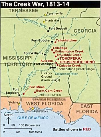
In late September and early October 1813, Tennessee volunteers mustered here on the Elk River for the Creek War; Andrew Jackson arrived on October 7, 1813, and the troops included John Coffee and David Crockett, according to markers and the Tennessee Encyclopedia. The campaign ended at Horseshoe Bend in 1814, and the Treaty of Fort Jackson took more than half of the Creek Nation's land. The state acquired the site in 2015; it is now about 40 acres with trails, interpretive signs and the statue 'The First Volunteer.'
Pioneer (Routt-Wells) Cemetery marker
A Tennessee Historical Commission marker says the nearby pioneer cemetery holds Revolutionary War soldiers Benjamin Porter (died 1828) and a soldier named Rowe (died 1829), and that Wells's grist mill operated here before 1809. The marker is listed here; the cemetery itself is not mapped because public access was not confirmed.
Driving directions (Google Maps)Sources
Isaac Conger House
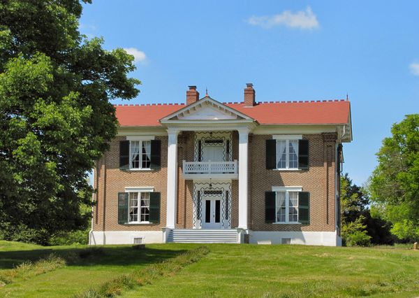
Built in 1808 in the Federal style, according to its National Register listing, the house predates the 1810 founding of Fayetteville. It was listed on the National Register on July 16, 1973.
Hidden gem: Built in 1808, two years before Fayetteville was laid out.
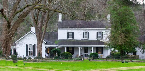
Childress House
Built in 1825, with a portico added in the 1840s, according to its National Register listing. It was listed on the National Register on February 25, 1982.
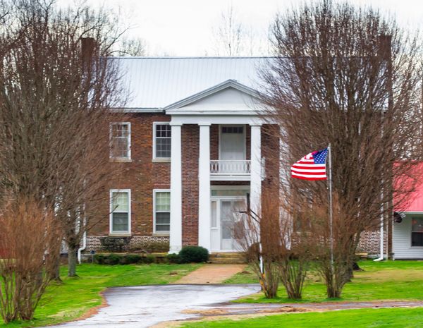
Mimosa School
A historic school building listed on the National Register on July 28, 1983.
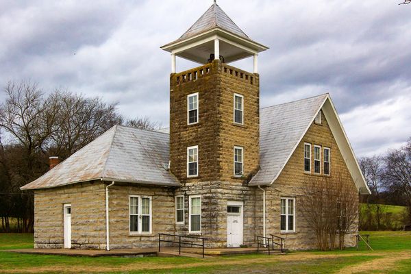
Toll Gate House
Listed on the National Register on May 11, 2026, according to the Wikipedia list of Lincoln County listings.
Hidden gem: Lincoln County's newest National Register listing, added in May 2026.
Driving directions (Google Maps)Harms Mill Hydroelectric Station
A hydroelectric station on the Elk River at State Route 15, listed on the National Register on July 5, 1990.
Hidden gem: The county's electric history on the river: a hydroelectric station listed on the National Register.
Driving directions (Google Maps)Whitaker-Motlow House
Built around 1850 and damaged in a 1909 tornado, according to its National Register listing, this brick house in the community of Mulberry was listed on the National Register in 2011.
Kelso Bowstring Arch Truss Bridge
A bowstring arch truss bridge on Stephens Creek Road near Kelso, listed on the National Register on January 4, 1983.
Driving directions (Google Maps)Get to know Fayetteville
Sources
All 68 sources
- Camp Blount Historic Site
- Fayetteville Main Street: History (The Douglas House)
- Fayetteville Main Street: Rose Hill Cemetery Stroll (Oct. 21, 2023)
- Fayetteville-Lincoln County Museum: About
- Find a Grave: Famous memorials in Rose Hill Cemetery
- Find a Grave: Old Fayetteville City Cemetery
- Find a Grave: Rose Hill Cemetery
- First Presbyterian Church Fayetteville: Our History
- HMdb: Bell's Route Trail of Tears
- HMdb: Birthplace of Ed Townsend (Tennessee Music Pathways)
- HMdb: Camp Blount
- HMdb: Camp Blount (THC)
- HMdb: Camp Blount Tablets
- HMdb: Confederate Park
- HMdb: Confederate Park Cannon
- HMdb: Confederate Soldiers
- HMdb: Fayetteville Calaboose Door
- HMdb: Horse Mounting Stones
- HMdb: In Memory of James Taylor Crawford
- HMdb: King's Mountain Messenger
- HMdb: Lincoln County
- HMdb: Lincoln County in the Civil War
- HMdb: Martyred
- HMdb: Pioneer Cemetery
- HMdb: Revolutionary War Patriots Memorial
- HMdb: Robert E. Lee School and The James Moores Home
- HMdb: St. Paul AME Church plaque
- HMdb: Stone Arch Bridge
- HMdb: Stone Bridge (THC)
- HMdb: The First Volunteer
- HMdb: The Stone Bridge
- HMdb: Trail of Tears Bell Removal Route
- HMdb: War Memorial for Lincoln County and City of Fayetteville
- HMdb: Women of the Confederacy
- HMdb: plaque at 301 Elk Ave. N.
- HMdb: plaque at 304 Elk Ave. S.
- HMdb: plaque at 310 Elk Ave. S.
- NPS NRHP record 00000731
- NPS NRHP record 03001003
- NPS NRHP record 82003986
- NPS NRHP record 84003579
- NPS NRHP record 84003580
- NPS NRHP record 88001060
- NPS NRHP record 89000127
- Our Town Almanac directory: Cahoots Restaurant
- Our Town Almanac directory: Stone Bridge Memorial Park
- Smithsonian (Save Outdoor Sculpture!): Confederate Monument, Fayetteville
- Tennessee Encyclopedia: Camp Blount
- Tennessee Encyclopedia: Lincoln County
- The Political Graveyard: Lincoln County, Tenn.
- WikiTree: Old Fayetteville City Cemetery (location)
- Wikimedia Commons: Pythian Building file description
- Wikimedia Commons: Queen Anne house in the district (1880s)
- Wikimedia Commons: house in the district (c. 1850, remodeled 1920s)
- Wikipedia NRHP list, Lincoln County
- Wikipedia: Borden Milk Plant
- Wikipedia: Camp Blount
- Wikipedia: Childress House
- Wikipedia: Fayetteville, Tennessee
- Wikipedia: Harms Mill Hydroelectric Station
- Wikipedia: Hugh Bright Douglas House
- Wikipedia: Isaac Conger House
- Wikipedia: Kelso Bowstring Arch Truss Bridge
- Wikipedia: McDonald–Bolner House
- Wikipedia: Mimosa School
- Wikipedia: Mount Zion Missionary Baptist Church (Fayetteville, Tennessee)
- Wikipedia: St. Paul African Methodist Episcopal Church (Fayetteville, Tennessee)
- Wikipedia: Whitaker-Motlow House
Walking distances and times: OSRM foot routing on OpenStreetMap data (routing.openstreetmap.de). Map tiles © OpenStreetMap contributors.
Photo credits
- 1886: a crowd at the earlier courthouse awaits the Bob Taylor–Alf Taylor debate for governor. T. V. McCown, 1886. Tennessee State Library and Archives. Public domain, via Wikimedia Commons. File page
- The north side of the courthouse square, College Street, with the Lincoln Theater (2015). Photo: Brian Stansberry, CC BY 3.0, via Wikimedia Commons. File page
- Today’s Lincoln County Courthouse, the county’s fourth, dates from 1970 (photo 2008). Photo: Ichabod, CC BY-SA 3.0, via Wikimedia Commons (resized). File page
- The Pythian Building, built about 1900 by the Knights of Pythias. Photo: Brian Stansberry, CC BY 3.0, via Wikimedia Commons. File page
- St. Paul A.M.E. Church. Photo: Brian Stansberry, CC BY 3.0, via Wikimedia Commons. File page
- Mount Zion Missionary Baptist Church. Photo: Brian Stansberry, CC BY 3.0, via Wikimedia Commons. File page
- The 1927 Borden Powdered Milk Plant, now the Fayetteville-Lincoln County Museum (NRHP). Photo: Brian Stansberry, CC BY 3.0, via Wikimedia Commons. File page
- McDonald-Bolner House. Photo: Brian Stansberry, CC BY 3.0, via Wikimedia Commons. File page
- In the South Elk Street Historic District. Photo: Brian Stansberry, CC BY 3.0, via Wikimedia Commons. File page
- The Old City Cemetery, a block east of the square (2006). Photo: Natalie Maynor, CC BY 2.0, via Wikimedia Commons (from Flickr; resized). File page
- In the Mulberry-Washington-Lincoln Historic District. Photo: Brian Stansberry, CC BY 3.0, via Wikimedia Commons. File page
- Hugh Bright Douglas House. Photo: Brian Stansberry, CC BY 3.0, via Wikimedia Commons. File page
- National Park Service map of the Creek War, 1813–14. Fayetteville is at the top: the march south began here. Map: U.S. National Park Service. Public domain, via Wikimedia Commons. File page
- Isaac Conger House. Photo: rossograph, CC BY-SA 4.0, via Wikimedia Commons (resized). File page
- Childress House. Photo: rossograph, CC BY-SA 4.0, via Wikimedia Commons (resized). File page
- Mimosa School. Photo: rossograph, CC BY-SA 4.0, via Wikimedia Commons (resized). File page
- Whitaker-Motlow House, Mulberry. Photo: Brian Stansberry, CC BY 3.0, via Wikimedia Commons. File page


Download the audio for offline
- Welcome (1:42)
- 1. The Courthouse Square (1:40)
- 2. Courthouse Lawn: Monuments and Markers (2:04)
- 3. The Pythian Building (1:27)
- 4. The Old City Calaboose (1867 town jail) (1:26)
- 5. St. Paul A.M.E. Church (1:32)
- 6. Rose Hill Cemetery (1:44)
- 7. Mount Zion Missionary Baptist Church (1:28)
- 8. Fayetteville-Lincoln County Museum (Borden Milk Plant) (1:31)
- 9. McDonald-Bolner House (1:13)
- 10. South Elk Street Historic District (1:25)
- 11. Old City Cemetery (1:42)
- 12. First Presbyterian Church (1:45)
- 13. Mulberry-Washington-Lincoln Historic District (1:25)
- 14. Hugh Bright Douglas House (1:32)
- Closing (1:37)
Every fact on this tour is attributed to a public source. Where sources disagree, both versions are shown. Spot a mistake? Tell us or share your story.